

Sep 11, 2026
El Niño is here! | Issue 224 | September 2026
And according to the weather people, it ain’t going away anytime soon.
At a recent meeting of primary industry bodies and government agencies, Fire Emergency NZ and Earth Sciences NZ (aka NIWA) provided analysis of the strengthening El Niño conditions around the world and in NZ as well as their forecasts for the next few months.
Key messages from Fire Emergency NZ were:
- Key driver for the coming season is El Niño is expected to be strengthening over the coming months. The first influence of El Niño is that throughout September there will be more frequent westerly winds.
- Potential areas to monitor in the August to October period includes lightly above normal fire potential in the eastern North Island (Manawatū-Whanganui, Hawkes Bay areas), and eastern South Island (above normal in central-north Canterbury, and slightly above normal in north and south Canterbury).


- Key messages from Earth Sciences NZ were:
- Dryness is going to develop quickly in the north/east: dry westerlies, and occasionally warm temperatures. Could line up well (with Australia warming up) for high temperatures occur.
- Cold snaps deep into spring – possibly beyond – expect volatile temperatures at times. Open to cold from the south. Some of the cold snaps still lead to drying.
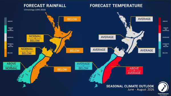
- Forecast rainfall outlook Sept to Nov: below for upper NI and east coast, normal or below for Taranaki/western LNI, Top of South and eastern coast SI, above west coast and Southland. Similar pattern for temperature.